
IRELAND
Why did we choose to go to Ireland? For one thing, although we began this hiking lark twenty years ago as just a pair, we have mushroomed into a quartet. Four years earlier, on the Dolomite trip, we met two somewhat younger and considerably more energetic women whose company we enjoyed, and they have been part of our trip planning ever since. It's a boon for us; not only are we flattered that they are willing to join forces with two old wrinklies like ourselves, but they invariably sign on for any harder walking or climbing option offered, and then tell us about it afterwards. That lets us feel like we've done it by osmosis. However, we now have four voices weighing in on where to go next, and among the four of us we've already been to much of the world. Miraculously, when Ireland (“The Wild Atlantic Way”) popped up on the short list, it won approval very quickly. A secondary reason was that one of us had been schooled in England, and was eager to hear what she correctly assumed would be the divergent Irish point of view.
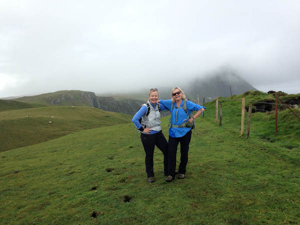 Fae and Carole
As usual, we planned to recover from jet lag by spending a couple of days in Dublin before the hike. The city had been invaded by some 25,000 Americans, alumni of Boston College and Georgia Tech, there to watch their teams duke it out in the Aer Lingus College Football Classic. As a result, the city didn't feel very foreign, but it was intensely interesting, and our walking tours added a number of books to our must-read lists.
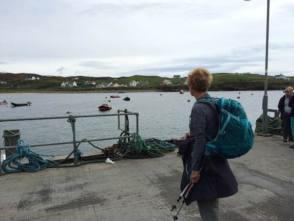
Two days later we caught an early morning bus for the two hour drive to Galway, on the opposite side of the country. There we awaited our guide, and over coffee and scones tried to furtively assess the fitness and companionability of the others in our group.
 Galway Bay
Perhaps the first thing that strikes the visitor to the west of Ireland is that he or she is now in Gaeltacht, meaning a predominantly “Irish” speaking area. The language commonly referred to by foreigners as “Gaelic” is known as “Irish” to the Irish. It has Celtic roots, and is related to languages spoken in Scotland, Wales and the Isle of Man. They are somewhat, but not entirely, mutually understandable. Irish uses the Roman alphabet, but has combinations of letters that confound non-Irish speakers. Galway, for instance, calls itself “Gaillimh.” Clifden is “An Clochán.” Tyrone is “Tir Eógain.” And so on. In the case of “Baile Átha Cliath,” it's best to stick to “Dublin.”
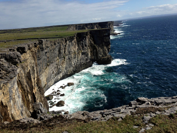
When our guide arrived we boarded a small bus for the drive around Galway Bay to the Cliffs of Moher. These are very high, very sheer, and eroding at a fast pace. And it was raining. Signs warn walkers not to get too close to the edge, and that seemed sensible. Whatever it was, the proximity to death, the dramatic scenery, or just generally being out of shape, it left us breathless.
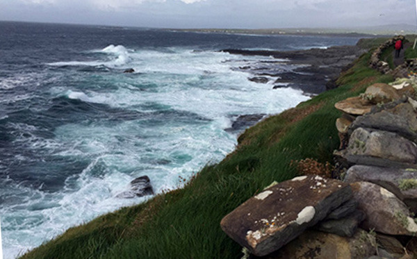
 Coastline near Galway Bay
Our hotel that night, in Ballyvaughan, was set in meticulously landscaped grounds and very comfortable, The plumbing was iffy but we are beginning to expect that. Wellington boots in all sizes were lined up in the entrance hallway, to be borrowed if and when needed. Emphasis on “when.”
The next day began with a short drive to The Burren (Irish: Boireann, meaning “great rock”). The smallest of the six National Parks in Ireland, The Burren is an area of limestone with deep fissures cutting through it. There are no paths; one walks gingerly, jumping over the cracks, from one flat place to the next. Lacking any better arable land and desperately hungry, the early settlers would drop seeds into the fissures, hoping something would take root and provide food. The land was so inhospitable that they had to haul seaweed up by hand from Galway Bay just to give their crops a fighting chance.
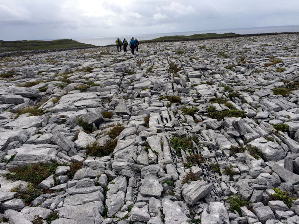 Waling on The Burren
That evening was the All-Ireland Hurling Final between Tipperary (Tiobraid Árann) and Kilkenny (Contae Chill Chainnigh). This was a big deal in the pub where we stopped to watch. The game, which the Irish have been playing for more than 3000 years, is a glorified egg and spoon race, in which a player bounces or balances a ball on a hurley (a more or less flat stick lacking the convenient “bowl” shape that would make it altogether too easy) while racing down a field half again as long as a football field, and hurling the ball full force to a teammate at the first sign of interference from the opposing team. It's an exciting game to watch. Tipperary came out on top, which suited the spectators in that pub.
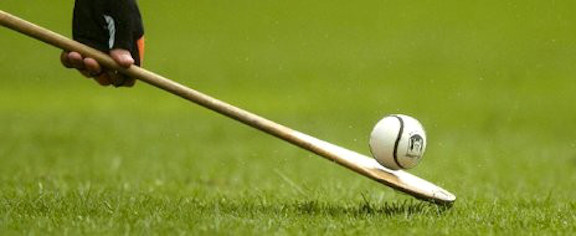 Hurley and ball
On most of our hikes there will be an evening briefing explaining what we will be up against the next day, but hikes in Ireland are more weather dependent than in other parts of the world. Not that the weather itself is unpredictable; you can more or less assume it will rain. But if ferries, visibility or slippery terrain feature on the day's agenda, adjustments are sometimes prudent. And sometimes those adjustments, such as ours on Day Three, turn out to have been unnecessary. Solid rain was forecast, but by the time that had given way to the bright sunshine that had not been forecast, it was too late to attempt the summit of Croagh Patrick, as per original plan. Instead we did a six-mile walk through crags and rocks before catching a ferry for the half hour ride to Clare Island, a mountainous island at the entrance to Clew Bay, in County Mayo.
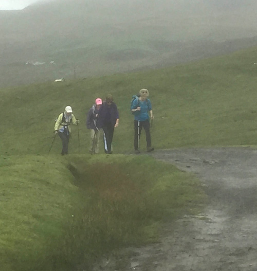 Stepping out into the mist
The island has an interesting history. It was part of lands owned by the powerful O'Malley family, one of whom was the fearless warrior chieftain Grace, or Gráinuaile (1530-1603). Accounts exist of a meeting between Grace and Queen Elizabeth I at Greenwich Palace. Grace arrived armed with demands of her own, and refused to bow to the Queen, showing a lack of respect that in those days was not considered conducive to a long life. That some level of agreement was reached between the two women attests to the formidable nature of both. It was also rumored that Grace had a small knife hidden in her garments, just in case. She must have felt quite strongly about whatever it was she wanted to discuss with the Queen.
 Arrival at Clare Island
The island is small, approximately 5 miles long and 3 miles wide, and mountainous. Fewer than 200 people live there, and some of those who do wear many hats. The good-natured proprietor of the guesthouse at which we stayed also owned (and piloted) the ferry service between the island and the mainland. When not doing that he drove the local island bus. But perhaps his greatest skill was in the kitchen; that evening he turned out a memorable dinner of fish chowder, cod with sweet potato puree and apple crumble. The person serving dinner that night we recognized as the woman who had unloaded all our luggage off the ferry and hoisted it effortlessly into a waiting van for the short trip to the guesthouse. By hopping into the van herself, she was able to get to the house before us walkers in order to distribute the room keys. The couple had three very young children, all impossibly handsome and well-mannered. Early the next morning we saw the mother attending to the chickens and various animals in the gardens around the house. We think she also ran an on-call taxi service, and there was some suggestion that she also worked at some kind of a part-time job, but by then our self-esteem was so low that we stopped listening.
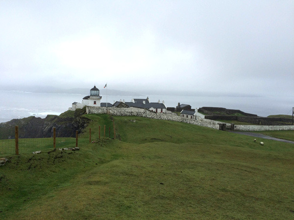 Clare Island Lighthouse
Our hike the next morning took us first past the Clare Island Lighthouse. The lighthouse was built in 1808, decommissioned in 1965 and transformed into a luxury guesthouse on a breathtaking promontory at the northernmost point on the island. We put any thoughts of luxury out of our minds and tramped on, along the edge of cliffs and up a very slippery 60° slope. Fortunately there were some occasional tussocks on which a foot could be planted; other than those there was nothing to prevent an embarrassing and swift descent to the bottom, and a restart of the entire climb.
 Steep ascent on Clare Island
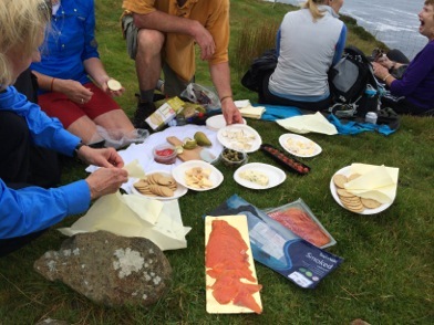
Once safely on flatter ground and out of the wind, a picnic was laid out: salmon, prosciutto, salami, Irish cheeses, crackers, and pears.
 PicnicWe were beginning to feel invincible when our guide made an announcement as to who among us should attempt what was coming next. There was a summit; it was behind this, behind that, and then behind things we couldn't even see from where we were. Or, we could immediately start the long descent. Several of us were gently directed toward choosing the latter, but this no longer bothers us. We gradually made our way downwards, at times sinking in up to our ankles in peat bogs. The sheep have a far worse time of it, though. When they land in a bog their wool gets so wet and heavy that they almost inevitably drown. From time to time we could just make out the rest of our group, now approaching the summit of Cnoc Mhor , the island's highest point at 1,600 ft. It was a long slog before we reached the small harbor. There, fortuitously, was a bar. And since it was the only bar on the island, we didn't want to neglect it.
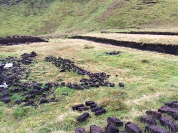 Peat
Peat
The next morning the proprietor and his wife managed to get their own children dressed, fed, and off to school, and all of us properly fortified by a “full Irish breakfast” before delivering us and our luggage to the ferry for the quick trip back to the mainland.
The rearranged schedule began with a stop at the Famine Monument in Murrisk. The stark bronze monument depicts a “coffin ship,” grotesque skeletons tangled in the rigging, and commemorates the Great Famine, 1845-1849, when, for five years in a row a blight (a strain of Phytophthora) destroyed completely the potato crops upon which many Irish relied. It is estimated that a million people starved, and perhaps twice that number set out in desperation for the United States, in overcrowded, often unseaworthy “coffin ships.” Some of the blame for the inadequate management of the situation rested with the British, and contributed to the resentment already felt towards Britain.
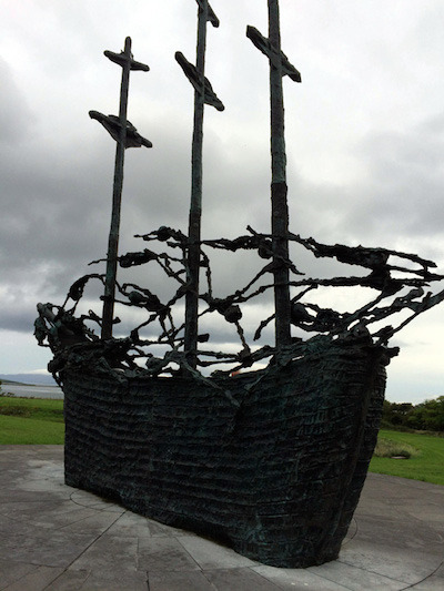 Famine Monument
Nearby was the entrance to Croagh Patrick (Cruach Phádraig) a 2,507 ft. mountain that has been a pilgrimage site for at least several millennia, first pagan, and later Christian. Saint Patrick is supposed to have fasted on the summit for forty days in 441 AD, and it is considered to be the holiest mountain in Ireland. Climbing it became so popular than an annual climb, involving thousands of people, has now been cancelled. However, one still can, and many still do. Some climbers choose to prove something to themselves or others by climbing it barefoot. The only thing we proved, by not climbing it at all, was a high level of empathy for others. The path to the top is mostly scree - steep and rocky – and we go slowly enough on such terrain to be an annoyance to the younger and fitter members in a group who will be forced to wait for us at some point. We regret it now, but we didn't then.
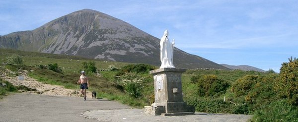 Courtesy of www.destinationwestport.com
Not nearly as challenging, but still rewarding, was the walk over the saddle of Mám Éan, the Pass of the Birds, through the Maumturk mountains. The path leads out of Joyce Country and into Connemara. Joyce Country takes its name from Thomas Joyce, a Welshman who emigrated to the area in the 14th century and amassed huge land holdings and political influence. James Joyce (1882 – 1941) is his most famous descendant. For some of the time we were without a guide, and had simply been instructed to “follow the track.” This we did obediently up to the point where we were surprised to notice that somewhere behind us the track had failed to follow us. We were briefly lost and disoriented, but a tiny stone chapel in the otherwise desolate landscape was a reassuring sight. Once we came over the saddle the late afternoon sunlight on the barren mountains of Connemara made for a hauntingly beautiful sight.
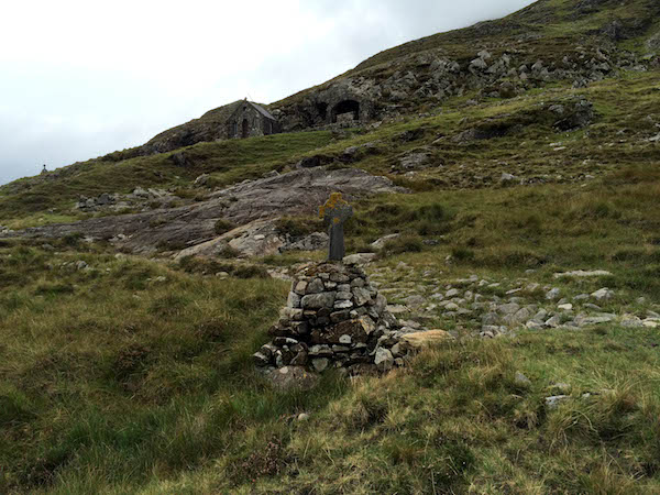 A Station of the Cross, near the tiny chapel on Mám Éan Pass
The next morning we were treated to a fascinating demonstration of sheep herding at a nearby farm. The farmer, himself an experienced trainer of sheep dogs, showed us what his current favorite trainee could do. With only a few words of instruction the dog was able to corral a large number of widely scattered sheep, and get them into the place where the farmer wanted them to be. The farmer needed to stand on a high spot from which he had a good overview, because the dog, once in the thick of things, had only the farmer's commands to go by. The farmer also had a small whistle, which told the dog to Stop. When asked about the range of the whistle, he confessed that he had no way of knowing since the dog had never failed to hear it yet. Training a dog ideally begins at around two years, and they can remain at the peak of their sheep herding careers until they are about five. A dog will bond with his trainer, and while he will accept the presence of a wife and children in the household, he will respond only to the person he considers to be the alpha male. While the farmer was explaining this, the dog stood quietly, quivering in anticipation while awaiting the farmer's command. Once given the signal to go, he zoomed off like greased lightning, easily bounding over any fence or hedge in his way. The sheep, for their part, reacted in panic. They consider dogs to be wolves, and although the dog (we were told) would never, ever harm one, the sheep don't know this. They jostled each other frantically, trying to get to where the dog wanted them to be. The farmer was justifiably proud of this dog.
The unrelenting rain continued the next day and doomed the planned excursion to the Aran Islands. Instead a local archeologist was produced to lead us on a walk to and around the Island of Omey. Omey is a tidal island that is accessible as long as you plan to go and return during low tide. Mistime your departure and you will be stuck. The 2011 population of the island was recorded to be one, and even if that one is still there, he or she is not running a bed and breakfast. It is, however, an archaeologist's delight. As our guide commented, the job of an archaeologist is essentially to dig through what were once garbage heaps and draw informed conclusions. The island has a monastic heritage and excavations have afforded insights into the life of early Christianity. Shell middens on the island date back to 1000 AD, and there is the ruined medieval Féichin's Church (Teampaill Féichin). Situated in a hollow, the small church deserves a visit if only because it allows for a few precious minutes of shelter from the fierce and incessant wind that is part of the island's charm.
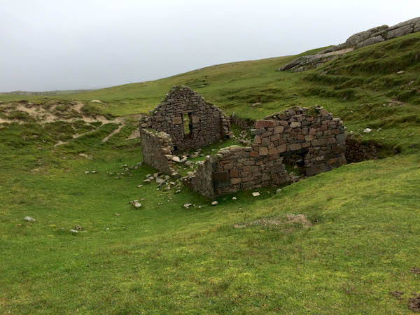 Féichin's Church on the Island Omey
Not a day too soon, as it was our last full day in Ireland, we awoke to a morning bright enough for us to fly to Inishmore (Inis Mór, meaning “big island”), the largest of the three Aran Islands. Little is known about the early history of these islands that lie within sight of the mainland. Megalithic monuments remain from the Stone Age, along with burial mounds and various objects from the Bronze Age. At some undetermined date, and from some undetermined place, the Celts arrived, bringing with them the language that is the main one spoken today on the islands.
A short drive from the airport through a patchwork scene of humble cottages set among small stone-walled fields, had us soon out of the urban sprawl and at the start of our hike. We walked atop sheer cliffs, navigated the same limestone surfaces we had encountered on The Burren, and clambered over countless stone walls, which was not as easy as it looked. The walls were loosely constructed without mortar of any kind, and tended to collapse just when you had got one leg on each side and thought you were safely over them. In places the walls had been built to within a foot or two of the top of the cliffs, and our guide would playfully insist that rather than going over the walls we could just go around the end. That would have left a few inches of unstable rock between us and a 300 foot straight drop into the Atlantic; climbing over every wall was an easy decision.
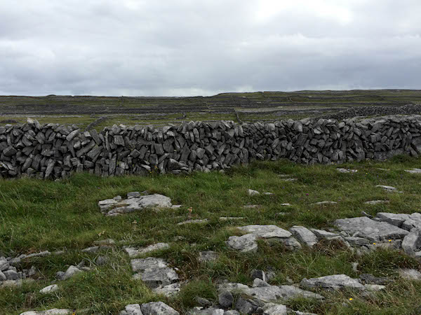 Stone wall
Shortly after a picnic lunch, laid out at a sensible remove from the top of the cliffs, our guide predicted that “the mother and father of all storms” was rapidly approaching, and we quickened our pace to get to the shelter of Dún Aenghusa. This is a large Stone Age fort. Or possibly not a fort; its function is debated to this day. Whatever it was, it is impressively fortified, with three almost concentric lines of ramparts. It may once have been completely circular; it extends right to the edge of cliffs, and it is possible that erosion has caused segments of the circle to fall off into the ocean. There is a large stone platform, possibly an altar, in the center, so it may have had some Pagan religious purpose. What it conspicuously lacked was a roof of any kind, so when the monstrous storm hit, as predicted, Dún Aenghusa offered no shelter to the modern day visitor. Of which there were throngs. From there it was all downhill to meet our van, drive to the airport, fly back to the mainland, and be driven to our hotel for a farewell dinner.
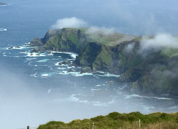
 Cliffs of Inishmore, one of the Aran Islands
We probably returned from Ireland with more questions than answers. You may dismiss leprechauns, wailing banshees, and the wee folk, along with the many monsters and demons from Celtic mythology, but you cannot dismiss the story-telling ability of the Irish. They don't need to kiss the Blarney Stone to acquire the gift of the gab. Recorded Irish history goes back only so far, and to explain what happened before that, legends have been told and retold with such wit and humor that it would be churlish to challenge them. The Irish love their stories, their literature and their poetry, and with every good reason. There was warmth and good humour everywhere we went, and very few awkward silences.
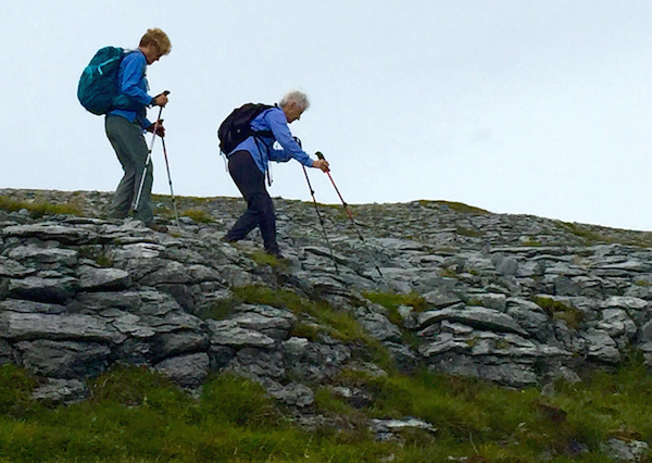
 Up (But Not Over) The Hill