Tour du Mont Blanc (1996)
We cut our hiking teeth (while eating very well) on this 100-mile circuit of the Mont Blanc massif, beginning and ending in Chamonix, France, and passing through Italy and Switzerland before completing the circle.
We took our first hike by default in 1996, when rationality reasserted itself and forced us to abandon our insane idea of climbing the Matterhorn. Casting around for something more in line with our inexperience, we settled on Mont Blanc, the highest mountain in the Alps (and satisfyingly higher than the Matterhorn). We made one minor adjustment: rather than attempting to summit, we would be walking around the mountain on what is perhaps the classic alpine walk, the Tour du Mont Blanc (TMB). An almost 100-mile long series of footpaths and roads, passing through France, Italy and Switzerland, loops around the granite peaks and glaciers of the Mont Blanc massif.
The circuit begins and ends in the French alpine resort of Chamonix. Nestled in a deep valley at the foot of the massif, Chamonix was for centuries an isolated village consisting of little more than a priory and some farms. The first recorded mention of it was in 1091, and the "accursed" mountains that would later become Chamonix's major asset brought only hardships to the early Chamoniards. After the conquest of Mont Blanc in 1786, however, a steady stream of visitors began arriving - Goethe, Victor Hugo, George Sand, Lord Byron, and Napoleon among them. In 1924 Chamonix was the site of the first Winter Olympic Games; today it is a leading center of alpinism in summer and skiing in winter. We arrived a day early, and on the afternoon of our arrival, contemplating Mont Blanc in brilliant sunshine from our hotel garden, we complimented ourselves on our wise decision.
That evening we met the rest of our group: thirteen people, ranging from experienced hikers to ourselves, who were still trying to grasp the concept of "wicking." (Capillary action that will help you keep dry if you’ve bought clothing that wicks. Denim, for instance, does not wick at all and is altogether wrong for hiking.) Our two guides briefed us. We would be taking a counter-clockwise direction around Mont Blanc, carrying in our backpacks only what was needed each day: warm clothes, rain gear, lunch, and water. On most days a van would transport our duffel bags, but one hut would be inaccessible by road.
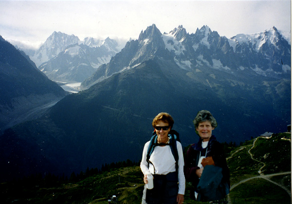
The “warm-up” hike the next day brought us face to face with some grim realities. We quickly realized that our pre-hike conditioning had been woefully inadequate. It had consisted of walking instead of driving whenever possible, and running up and down several flights of stairs each day. While not exactly a regimen, it was purposeful, and we had felt smugly prepared for anything the Alps might have in store. The first hundred yards of the hike were no trouble at all, and we undoubtedly would have done equally well on the remaining five miles had it not been for the altitude and our absurdly heavy backpacks. 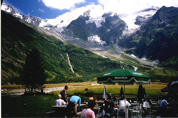 Glacier du Miage is in the backgroundHowever, the more significant result of the warm-up hike was the loss of one of our two guides. Possibly feeling a bit frolicsome, he decided to get a group “before” photograph. Ellie suggested (innocently, she insists) that he step backwards a few feet in order to get a better angle, and he obediently complied, failing to notice that the mountain dropped off right behind him. We needed two guides - one to shepherd us along the route and a second to drive the back-up van that would meet us each evening. Now that he had broken his ankle we were one guide short and a replacement had to be hastily found. A young English-speaking woman materialized whose only apparent qualifications as a guide appeared to be the fact that she was friendly and in possession of a map of the region, but in the event, she did a fine job.
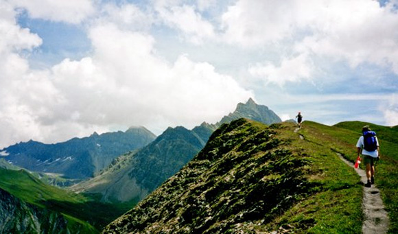
The following morning we set out on the TMB. Our morning routine seldom varied: breakfast at 7.30, duffels in the van by 8.00, a quick sortie to buy food for lunch, and departure at 8.30. We were driven to Les Houches, a nearby farming village, and took our only mechanically-assisted ascent on the hike: a cable car to the Col de Voza (5,372 ft.). Since a col is an elevated pass between two valleys, we were immediately treated to a long downhill hike across meadows to the snout of the huge Bionnassay Glacier. But then came pay-back time. In retrospect, our naive concept of the TMB was that we would choose a contour line and march comfortably around the mountain at a more or less constant altitude. The reality of cols and valleys only hit us as we left the Bionnassay and headed for the Col de Tricot (6,954 ft.). If it was hard work for us, it was even harder on our guide, an affable and capable Australian. He was responsible for thirteen hikers of greatly varying ability, and was constantly doubling back between the vanguard and the rear - a distance sometimes so wide that Ellie was once heard to observe that some of us were probably in a different time zone from those in front.
Near the top of the col we came across a shepherd, whose flock of sheep were determined to share our lunches. We fought them off, and tucked eagerly into our paniers de Provence and quiches Lorraine; the more experienced hikers in the group had reached the summit long before us and were sensibly nibbling trail mix.
From the col we could see our next destination: a spectacular valley with a few chalets, one of which was a café! Meaning, coffee! We sat in the sun with our bowls (the locals understand thirst) of café au lait, our sense of well-being complete, and admired the picture-perfect Dômes de Miage.
Then it was up again, over a hill called Truc, and down the other side to the village of Les Contamines, where we arrived feeling a bit bloodied, but unbowed.
 Descent into Les ContaminesAt dinner that evening our guide cautioned us that the next day's hike was one of the hardest on the TMB. Anyone with misgivings could go by van - three hours of mountain roads. The following morning we awoke to a steady downpour that gave us momentary doubts, but in the end we took the moral high ground - a decision based partly on childhood memories of what hairpin bends can do to the breakfast you just ate, and partly on the unspoken determination on both our parts never to be the first to chicken out. Clad in everything waterproof we owned, seven of us set out along the valley floor, past the tiny Baroque church of Notre Dame de la Gorge, an old pilgrimage site. Immediately we were on what was once a Roman road, and the pitch of it sparked a renewed admiration for the Romans and their ambition to enlarge their empire on the far side of the Alps. Our attention was directed to ruts said to have been caused by chariot wheels, but they received from us the same skepticism with which we view marks reported to have been left by wagon trains in the American West.
At first there were a few huts along the way, and we stopped at every one of them, mainly to get out of the rain, but also because we women never knew where the next toilette would be or what it would be like. By mid-morning, however, the rain had stopped, and we were climbing up through a rocky, treeless gorge towards the Col de Bonhomme, where we stopped for lunch. There was a hut at the top, but it was already filled to capacity with a steaming mass of humanity trying to find some shelter from the cold. Within minutes we had piled on every stitch of warm clothing we had with us, including gloves, and we ate our lunches huddled on the lee side of the small stone hut.
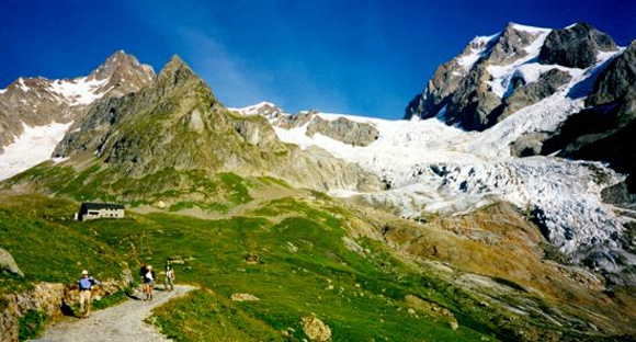
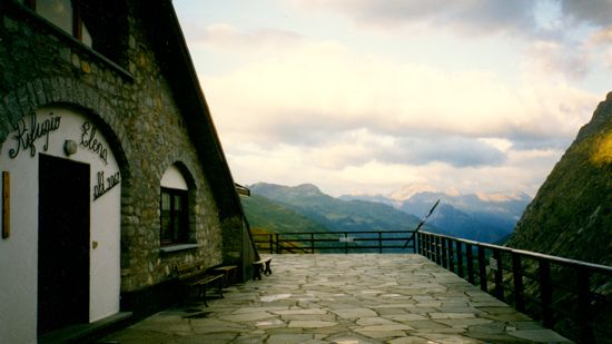
With no reason to linger, we soldiered on to the still higher Col de la Croix-de-Bonhomme (7,144 ft.). By now we were enveloped in thick clouds which obscured what were said to be wonderful views but which leant a surreal mood to the wild terrain. As we made our descent, the bleak scenery gave way to pastures, and at last we arrived at the remote summer village of Les Chapieux, consisting of a hut (or refuge), a youth hostel, a campground, and a goat cheese farm. We settled into what struck us at the time as Spartan accommodations (little did we know!), regaled those who had opted for the van with highly exaggerated accounts of our exhausting and hazardous hike, and turned our attention to one of the reasons we had chosen this particular trip: as expected, even the most humble refuges in that part of Europe have more than adequate kitchens. 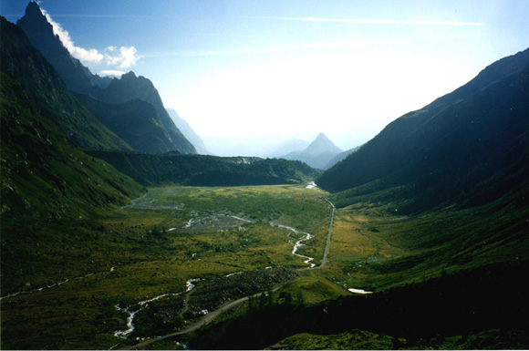 View of the Val Veni from Rifugio ElisabettaThe following night was to be spent in the Rifugio Elisabetta - a hut operated by the Italian Alpine Club. As it is inaccessible by road, we had to carry everything we would need for the next two days. Thus laden, we struggled up to the Col de la Seigne - the border between France and Italy. Rumor has it that overly zealous - and bored - Italian army conscripts will sometimes take it upon themselves to patrol the border to check passports, but we saw neither officials nor even any indication of a border. In stepping from France into Italy at that spot, one is also crossing the hydrologic divide between the Adriatic and Mediterranean seas. We, however, were more interested in lunch than in hydrologic divides, and on this day the guides had organized a picnic. In a sheltered spot under the col we attacked an extensive array of cheeses, meats, bread and fruits, washed down with a local wine. Then we were off on the long trek down to Elisabetta.
 Rifugio ElisabettaThe refuge was dramatically situated at the foot of two glaciers. Dormitories occupied the top floor, but the middle floor had bedrooms, one of which we were to have. It was a small room, and the "we" consisted of two couples and three "single" women. After dinner we gathered outside for "grolla" - a lethal concoction of various grappas, served hot in an odd-looking pot with spouts sticking out in all directions. A funny thing happened as the grolla pot made its rounds. The prospect of seven of us bedding down in a room scarcely larger than two billiard tables, so unappealing a short time earlier, now struck us as not only tolerable, but actually funny. And by the time the pot was empty, the idea seemed hilarious. Back in the room, we were merrily giving vent to the humor we saw in the situation when the door opened, and a small person - probably a child of the family operating the refuge - stepped into the room and barked: "Please. STOP." Exit right, to stunned silence from audience. We had just learned a cardinal rule of refuges: at a given time all talking ceases, and the entire contents of the refuge falls asleep. From one of the upper bunks emanated a whispered comment on the apparent role reversal, with the children now telling the grown-ups when to go to sleep, but the rest was obedient silence.
 Ellie in the Val VeniThe next day we set out in high spirits, cheered by the prospect of a cooked, not packed, lunch, and a bed that night in the Italian resort of Courmayeur. We began with a long, level walk along another Roman route, through the wide Val Veni, with the immense moraine of the Glacier du Miage on one side. Then, inevitably, we headed up, through fields brilliant with wildflowers. We were fortunate to share part of the trail with an young Milanese naturalist, who treated us to a guided tour of the flora as we went along. She explained that the piercing calls that we heard reverberating across the valleys were marmots, relatives of woodchucks, warning each other that danger approached. And if humans represented danger, the marmots were right to be concerned; for the first time since setting out the trails were becoming almost crowded. We were clearly approaching Courmayeur.
 Lunch on the terrace above CourmayeurLunch had been arranged at a restaurant atop the Col Chécroui, a sunny terrace high above Courmayeur. While waiting for Giacomo, the owner and chef, to work his magic on an outdoor grill, we contemplated the Italian side of what was now Monte Bianco. This is the steeper side of the mountain, and is considered to be a much more challenging route to the summit.
A chairlift-cable car combination connects Col Chécroui with Courmayeur, and only to save a bit of time (honestly!) so we could look around the famous resort, we availed ourselves of it. As we had been incommunicado for some days, the two of us wanted to find telephones to assure our husbands of our continuing existence, and that done, we indulged in the frothiest, most delicious, most elegantly served cups of cappuccino ever.
The next day's hike required decisions, as there were two possibilities. Option A allowed time for shopping and lunch in Courmayeur, followed by a relatively easy hike, and Option B called for swift purchase of lunch provisions, and immediate departure on what promised to be a long and grueling day. Still flushed from not having totally disgraced ourselves on the Col de la Croix-de-Bonhomme, we opted for the latter and hastened to the small market to buy provisions. Hampered by our very rudimentary Italian and the knowledge that everyone else was already waiting for us, we made what turned out to be a very poor selection: focaccia. We were given to understand that it would be better heated, but in an emergency could be eaten cold.
This time we were eight hardy souls and after a particularly steep climb through a forest, we found ourselves atop a high ridge above the Val Ferret with glorious views, "three-sixties," all around. Everything would have been right with the world had not a squadron of focaccia-deprived flies sensed what was in our backpacks. Never was there such a determined attack (although our guide insisted that these flies were amateurs compared to those on Australian sheep farms). They knew how to land, but had apparently forgotten the procedure for taking off. Eventually we begged for permission to stop for lunch, and solved the problem by eating the offending focaccia while walking briskly around in circles.
 Val FerretWe continued along the ridge for what seemed like miles, always with the Mont Blanc massif magnificently in view. Among the few hikers we encountered were two Scots who told us they had fallen "off the mountain" the night before, and in the dark had been forced to bivouac where they were until daylight. Although not seriously injured, they were cold, hungry, and disoriented, and were relieved to learn from our guide (with whom they shared a more or less common language) where the nearest refuge was.
Our own route eventually forsook the ridge and led down a barren rocky valley that looked more lunar than earthly. Stones gave way to pastures as we descended, and we stopped to chat with a cowherd at his isolated barn, who told us that in his younger days he had completed the Tour du Mont Blanc in four days. Somewhat humbled, we struggled on down to the bottom of the valley, where our van was waiting to drive us to the isolated Rifugio Elena - our shelter for the night. The refuge was splendidly located overlooking two glaciers, the Glacier de Pré de Bar and the Glacier de Triolet. More modern than Elisabetta, each dormitory accommodated about fifty people - men and women - in bunkbeds. We had just finished dinner when our two Scottish mountaineers tramped in, looking even more bedraggled than when last seen on the trail. We kindly, but firmly, pointed them in the direction of the showers; they might, after all, be assigned bunks near ours.
 Rifugio ElenaRefuges offer little beside food and beds, and most hikers turn in early, but one of us, the more indefatigable one, decided to treat the guides to some beers. The more sensible one unpacked her backpack, made up her bunkbed, and climbed into it. Ellie had done none of those things, and when all lights snapped off at exactly 9.30 pm, she was still somewhere in the refuge, but not in the dormitory. She would have to find, in what was now total darkness, the one empty bed in a room containing twenty-five identical ones - each occupied, one could assume, by a soundly sleeping European hiker who would undoubtedly object to being disturbed by a rule-breaking American. Eventually a brief flicker of light indicated that the door to the hallway had opened and closed. In the stillness Ellie could be heard groping her way through the aisles, offering whispered but explicit comments about what she thought of this early lights-out policy, and wondering where in the you-know-what her bunk was. Her loyal friend waited, flashlight in hand, ready to pilot her to her berth when she got near enough. Later that night a great storm passed through; bursts of lightning briefly illuminated the sleeping dormitory, and thunderclaps reverberated across the valley.
 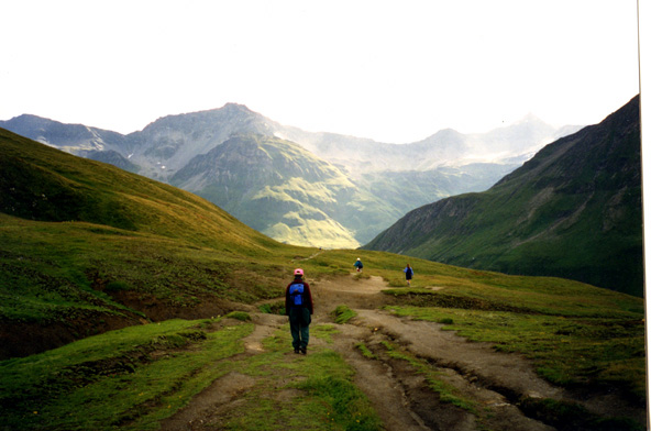 Near the Italian-Swiss borderThe following day we hiked over the Grand Col Ferret into Switzerland. Perhaps it is mind over matter, but it seemed to us that the paths in Switzerland were better maintained, the routes better marked, and the cows better behaved than those in Italy. They were still cows, however, and as we marched through one herd we were reminded of the cardinal rule in encounters between man and animal on mountain paths: always keep to the uphill side as animals do not yield right of way, and will feel no remorse if they knock you off the path and down the mountain.
In the tiny village of Ferret we stopped for coffee, and watched several Valaisienne families enjoying their Sunday dinners. Plates piled high with pommes frites caused us momentary regret that we were to have a picnic lunch a little later, but our guides did another bang-up job, and although a shower forced us to eat under the shelter of a small chapel, our lunch of local produce and wines was a good one. We then hiked along a road to a slightly larger village, La Fouly, and luxuriated in a Swiss hotel: spotless rooms, warm duvets, and bathrooms en suite. And at dinner that night, mounds of pommes frites to accompany the roast chicken.
The next day we had to hoist the white flag. It was raining, we both thought we were coming down with colds, and the hike was a relatively short one to the Swiss resort of Champex. We piled into the van with no regrets, and relaxed in the picturesque village and around the lake while awaiting the hikers. The hotel there was able to receive CNN - our first glimpse at the outside world in a week.
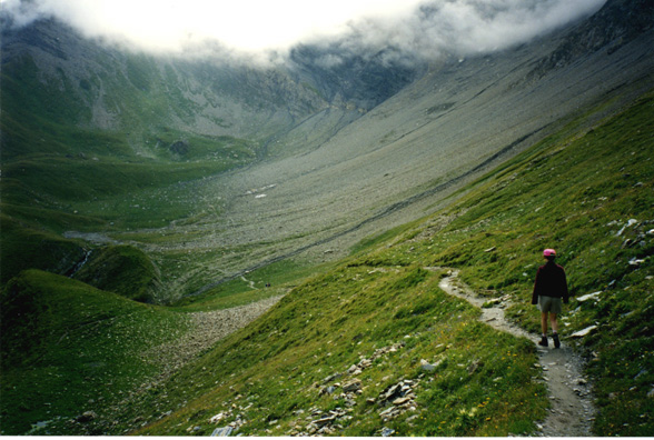
We were to spend two nights in Champex, with a day of rest scheduled in between. Those who wished to could go by van to the Swiss city of Martigny, and this we did, but apart from an excellent Manet exhibition at the Pierre Giannada Foundation we found being in city streets after a week of mountain solitude more jarring than pleasurable.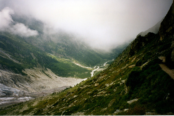 Descent from Fenêtre d'Arpette, SwitzerlandMore than eager to hike again, we set out from Champex on what was billed as the toughest segment of all. It began in a glacial valley, the Val d'Arpette, and worked up to an unforgiving scramble over large rocks to the Fenêtre d'Arpette (8,760 ft.) - literally a "window" or notch in the col. By the time we got to the rocks we were in clouds, and there was no path as such. But this being Switzerland, the route was conscientiously marked with red and white stripes on the rocks, just close enough together that one's next objective was always visible, even in poor conditions. The experience of navigating the ascent over the rocks, unable to see ahead or behind, in near solitude, was exhilarating. From the top there were breathtaking views of the Trient Glacier. Turquoise crevasses gaped with menacing beauty, and jagged séracs, or ice pinnacles, stood poised to break at any moment. With binoculars we could make out ice-climbers practicing on the glacier.
 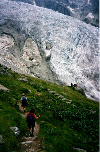 Glacier de TrientThe path down from the col was as long and as steep as the route up, but not as taxing on the lungs. The van met us at the end of the trail, and drove us to the only hotel in the small village of Trient. Most of the hotels on the Tour du Mont Blanc have dormitories to accommodate as many hikers as possible, and are often filled to capacity during the summer. This was no exception, and getting through the crowd of youngsters massed outside the front door took maneuvering. Ablutions were performed in communal sinks, and the line for showers was long. But the food was excellent (a cheese and tomato fondue served over small new potatoes), and all noise stopped at an hour when our own children, back home, would still have been formulating their evening's plans.
Our last day's hike took us over the Col de Balme (7,234 ft.), the border between Switzerland and France, and back to Chamonix. It may have been the fact that we were now in full hiker mode, or that the end was in sight (although not yet literally), but for whatever reason, the climb that day was pure enjoyment, and when we reached the final col and were given the option of taking a cable-car down (with an intermediate stop at a good restaurant), or skipping lunch and walking for a few more hours to the end of the trail near Chamonix, we did not even debate it. We wanted to know that we had closed the circle on our own feet. As we descended we could see La Flégère, where we had "warmed up," however long ago.  Col de Balme: closing the circle back to ChamonixAt dinner that night we said farewell to people who, over the course of a hundred miles, shared sleeping quarters, and mutual encouragement, had became fine traveling companions. We were not disheartened to learn that what had taken us ten days has been done in as few as twenty-two hours; the racers who enter the Tour du Mont Blanc competition are seeking a different kind of prize. But we too brought home trophies: in addition to improved physical plants we had both gained a new confidence in our own capabilities. And on the flight home from Geneva we were already discussing where we would go next.
Click here to see a gallery of the photos